Friday, June 26, 2009

Little Big Horn

Critters seen on 2009 trip so far: beaver, groundhog, prairie dogs, big horn sheep, buffalo (bison), white tail deer, chipmunks, pronghorn, burros

It was on to Hardin, MT, not far from the Little Bighorn Battlefield National Monument (http://www.nps.gov/libi/), driving through the Northern Cheyenne and Crow Indian Reservations. In fact the Monument and battlefield are located within the Crow Reservation. We knew that the couple days we would be in town were over the annual Little Big Horn Days (132nd annual to be exact), but we didn’t realize that the one day, June 25, was the actual 133rd anniversary of the battle. As we found out, being there on the actual anniversary was good and bad. Good because special events were going on not otherwise seen, and bad because it was extremely crowded and you never knew when anything was really happening.

Besides all the activities scheduled in Hardin and the surrounding area June 24-28, there were several special performances and events scheduled at the Monument. However, we soon learned not to trust the time something was scheduled because it might start earlier or later for as we were told by a park ranger, the events run by the American Indians operated on “Indian time”. Consequently scheduled events by the park service might have to be jostled depending on when the tribes started or finished their event. We never did see the orientation film at the visitor center because both times we went to the room where it was being shown, it had already started or was about to end, and there was standing room only with really no view of the screen from where we were. Oh, well, we got plenty of info from the exhibits and the brochures.

As we walked from the parking lot, we passed the tail end of a dedication of some sort by one of the tribes. A short time later across from the visitor center we saw a number of people on horseback. As we learned from a flyer, it was a Lakota presentation regarding the battle. They were across the field and a number of people had walked down to the end of a walkway watching. Soon those on horseback began riding in a circle, whooping and hollering, carrying their tribal flags, and then they charged towards the group of bystanders. A short time later they dismounted and stayed in that area for quite a long while. Either this entire presentation lasted several hours, or there was more than one right after the other. It was blazing hot (96 degrees) and as you can see in the photo, there were no trees in that area.


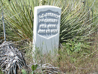
We chose to walk the grounds near the visitor center, through the national cemetery, and then got in our car and drove the Battlefield Road, reading the exhibit markers. On Last Stand Hill, a uniformed soldier stood holding the American flag in front of the 7th Cavalry Memorial. The remains of 220 soldiers, scouts, and civilians are buried around the base of the memorial, but Gen. Custer’s remains are buried at West Point. Across from the Cavalry Memorial is the Indian Memorial which was dedicated on the anniversary date in 2003. The battlefield is dotted with white markers that were erected in 1890 by the Army indicating the spots where Custer’s men fell. In 1999 the National Park Service began erecting red granite markers at various sites of Cheyenne and Lakota casualties.


On our way back to the campground, we took a couple back roads instead of the highway and spotted several horse trailers near some grandstands. We pulled into the parking lot across the street and discovered that it was the first day of Crow Fair & Rodeo. Not many people were in the stands, but we stood underneath in some shade and watched the calf roping for a spell. Even saw one of the riders fall off his horse coming out of the gate!

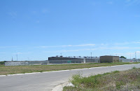
The day before when we arrived we were told that a few people had set up booths in historic downtown Hardin selling Indian tacos, and they weren’t to be missed. We found two (evidently more would be setting up the next day), and stopped to chat with Georgy and Bill. As it turns out, Georgy is a three time mild chili champion, and this was her first year to set up a booth. And we discovered that her husband, Bill, was once again portraying Chief Sitting Bull in the reenactment to be held a few days later. Indian tacos are basically a taco served open face on Indian fry bread (kind of like a really thick, fried tortilla). Russ had never eaten one so we each got our own, and they was some mighty fine eatin'. We chatted as we ate, and Bill happened to mention about the empty prison behind the IGA down the street. Seems this state-of-the-art prison has been sitting empty for the last two years after having been built with bond money. Word is that politics has kept it empty and no prisoner has ever set foot in it. Russ jokingly said to Bill that perhaps someone should call Pres. Obama since he’s looking for somewhere to put the Gitmo detainees. As it turns out, they already have! And they’ve been turned down. Bill said every news agency from around the world has descended on Hardin talking to the locals about the situation. In fact while we were there a crew from Holland was in town and had been interviewing them earlier in the day. You can read one of the many articles in the following link for all the details: http://www.cnn.com/2009/US/05/26/montana.gitmo.west/. Quite an amazing story, and here are a couple photos.


Also in the area is the Big Horn County Historical Museum (http://www.bighorncountymuseum.org/), and since it was free, we decided to check it out. The museum complex consists of twenty historic structures, two exhibit buildings, and one main building housing the visitor center, gift shop, and a rotating exhibit on 22 acres. The original 1911 farmhouse and 1916 barn along with the land were donated in 1979, and the other historic buildings were moved to the museum from various locations within the county. There is a 1937 gas station, farm equipment of all varieties and sizes, train depot, 1917 church, slaughterhouse, 1918 post office, and 1922 schoolhouse just to name a few. If you look closely at the picture of the old truck, you’ll notice that the rubber has entirely worn off one of the front wheels while there’s still a little tread on the other front tire and rear ones. It was an interesting place full of history and had it not been so blasted hot, we probably would have stayed a little longer.


We stayed at the Hardin KOA, and though not a large campground, we had a very nice site at the back with a wheat field behind and a large shade tree that didn’t interfere with our satellite reception. After a couple nights here, it was time to move on the Great Falls, MT.

Wednesday, June 24, 2009

No Aliens or UFOs

Critters seen on 2009 trip so far: beaver, groundhog, prairie dogs, big horn sheep, buffalo (bison), white tail deer, chipmunks, pronghorns, burros

Our next stop was Devils Tower, WY. You know, the place made famous by Close Encounters of the Third Kind. We stayed at the KOA just outside the park entrance to Devils Tower National Monument (http://www.nps.gov/deto/) and as you can see, we had a pretty nice view. Shame we don’t have a window in the back of the RV! We were parked right across from the large community campfire which is lit nightly at 7pm for anyone's use, and then at 9pm every night they show the Close Encounters movie!


Devils Tower is 5, 112 feet above sea level, 1,267 above the river that helped form it, and 867 feet from its base to the top. In 1906 Devils Tower was proclaimed the first national monument, and today thousands of visitors come every year to marvel at this sight. Nearly 5,000 climbers come from all over the world annually to climb its massive columns. Contrary to popular belief, the tower did not rise up from the ground through the earth. Instead the process began 60 million years ago as molten magma pushed up into the sedimentary rock above it. As the magma cooled, it contracted and fractured into the grooved columns. Over millions of years the softer rock and sediment surrounding the hard volcanic rock eroded away exposing the tower. (We also learned that the nearby Little Missouri Buttes were formed at the same time in the same way.)

The area is sacred ground to many American Indian tribes and is still used for ceremonies and worship today. Many of these ceremonies occur during the month of June, and there is a ban on climbing during this time. Throughout the park you see prayer cloths or bundles tied to trees. These are brightly colored cloths that sometimes contain herbs, tobacco, or something symbolic to the individual, and after a prayer is said, the cloth is tied to the tree so the wind may blow the prayer up to the Great Spirit. According to Native American legends, the columns on the tower were created by claw marks of a large bear, and each tribe has their own version of how this occurred. This photo of a painting in the visitor center depicts the Kiowa legend.

At the nearby picnic area is the circle of sacred smoke sculpture honoring the American people created as a gesture of world peace. The sculpture, dedicated in 2008, represents the first puff of smoke from a newly lit pipe.

We decided to take the 1.3 mile ranger-led Tower Trail walk that circles the base of the tower giving you up close views of all its sides. The trail is paved and not too strenuous though one spot is a little more uphill. Our guide was not actually a ranger but rather worked for the forest service and we have a feeling it may have been one of his first times leading a group. We have no doubt he is extremely knowledgeable and intelligent but was just not good at relaying information and answering questions for the group. However, we enjoyed the walk through the pines and the beauty of the tower and its surroundings. And you can see Russ back to his rock climbing (sort of) in one of the pictures below!


We only stayed a couple days in this area as there’s really not much more to do, and since we didn’t see any aliens or UFOs, we figured it was time to move on.

Tuesday, June 23, 2009

The Black Hills

We’ve been amazed at how much there is to see in South Dakota and to think we’ve only been in the bottom third of the state! In the Rapid City area, you’re not only close to Mt. Rushmore and the Crazy Horse Memorial, but also to some of the most beautiful scenery we have seen on our journey thus far, nearly all located in the Black Hills National Forest. In this blog entry I’m going to tell a little about each area we visited and then post several pictures because as they say pictures are worth a thousand words.

Wind Cave National Park

There are two impressive caves in the area but Wind Cave was the closest and the one we chose to visit. However, we had already decided we weren’t going to spend the money to go in the cave but instead we’d stop at the visitor center and then travel the scenic roads throughout the park. Wind Cave National Park (http://www.nps.gov/wica/) was the first cave to be designated a national park and has several unusual formations. The park covers 28,295 acres of open prairie and home to bison, pronghorn, prairie dogs, ferrets, and elk. Driving along we came upon a large number of bison including several reddish-brown calves grazing in the fields. As we stood watching, suddenly from behind a knoll five pronghorns came running out onto the field! Soon a few more joined them, drinking from the pond and grazing in the fields as well. A few minutes later two of the pronghorns began locking horns, but I don’t believe they were fighting but merely playing.


As we continued our drive out of the park, we came across the town of Hot Springs, SD, driving through the historic downtown district with several pink sandstone buildings dating back to the early 1900s.


Custer State Park

Within Custer State Park (http://www.sdgfp.info/Parks/Regions/Custer/custersp.htmhtm) are three scenic areas: Needles Highway, Iron Mountain Road, and Wildlife Loop Road. Nearly 1,600 bison/buffalo freely roam this 71,000 acre park in the Black Hills. Since there was so much to see, we spread our drives over several days. One morning we loaded the dogs in the car and took off for the park planning to drive Needles Highway and the Wildlife Loop Road. Shortly after entering the park, we saw this bison on the side of the road pretty much ignoring everyone while grazing. However you don’t want to mess with bison!

Needles Highway is a 14-mile road that twists and turns its way past tall pines, towering rock formations, and through narrow tunnels. Along the highway are 3 of the 6 hard rock tunnels located within the park, 4 of which are one lane…watch carefully and honk before entering! We went through two that were roughly 12’ tall and 9’ or slightly less wide. Russ has become quite the climber it seems as you can see him perched near the top of one of the tunnels when you open the picture. The road’s name comes from the needle-like granite formations that seem to pierce the sky, and there is one formation in particular called the Needle’s Eye because of the opening created by erosion that makes it appear like the eye of a needle. There are also a series of pinnacles that resemble church spires called the Cathedral Spires.


Our drive took us to a height of 6,363 feet with incredible views. We stopped at the Sylvan Lake Campground to check it out and there we met Tarrah, who works for the SD State Park Service. She loved meeting the dogs as she was a vet tech for awhile in CO, but she says that Custer State Park always draws her back as this is her 3rd year working for the park. She loves the area and we thoroughly enjoyed spending probably half an hour talking with her. What a great gal and we wish her all the best in her future endeavors.

Shortly after we began driving on the 18 mile Wildlife Loop Road, a bison crossed the road right in front of us. Told you they roam freely! And then we met the “begging burros” who also roam freely. These creatures stand in the middle of the road, poke their noses in car windows, and take just about any food you’re willing to give them. Everyone gets out of their car to pet and/or feed them and of course take pictures. You’re warned not to feed the wildlife and to be careful approaching them because they are still wild animals. Of course, we got out of the car, and Russ walked over to pet one. We didn’t have any food, but a lady in one of the cars gave Russ a slice of bread to feed him, and the burro seemed hesitant at first. So Russ told the burro (yes, he was talking to the animals) that he wasn’t going to beg him to take the bread, which is what’s he’s saying in the photo. The burro did finally take it. Further along the drive we saw more pronghorn, buffalo, and some mule deer. We’re so glad we had the time to truly enjoy both these roads and not have to rush. The beauty cannot be truly described in these paragraphs or even in the pictures.

The next day we again loaded the dogs in the car to drive the 17 mile Iron Mountain Road. Completed in the 1930s, this road has twists and turns, 3 more tunnels (one of which is one lane), and pigtail bridges meaning the road curls and passes over itself. These bridges enabled road engineers to reduce elevation without needing to build a switchback. Iron Mountain Road is one way of getting to Mount Rushmore and the three granite tunnels frame Mount Rushmore perfectly in the distance. What an incredible view!


On this drive we saw more pronghorn and once again ran into a group of burros in the middle of the road. Of course we got out again, but this time Russ had the camera. Three of them were right next to my door, nearly making it difficult for me to get out. One had an itch behind his ear and kept trying to scratch it on the side view mirror. At one point I thought the mirror was going to come off! Again we had no food for them, so I tried to explain that to one of the burros. The dogs really wanted to go out and play, barking and whining at the burros, and at one point Mikey was nearly nose to nose with one through the slightly opened window!

Both days we saw hundreds of piled logs and branches throughout the forests. Our guess was that they were burn piles for prescribed burns which is a policy of the National Park Service. We figured it must take an army to make all those piles, but we learned from one of the park rangers that actually about 4-6 individual contractors do all the work. He said it is quite a sight to see, this small crew hustling and moving from one section to the next.

City of Presidents

Rapid City, SD, is known as the City of Presidents because of its life-size bronze sculptures of 35 past U.S. presidents that are on display throughout the downtown 15 square block area. This project was begun in 2000 with 4 sculptures and each year thereafter two of the early presidents and two from the modern years have been added. I didn’t get pictures of all but below are four that came out pretty good: Grant, JFK with John-John, Teddy Roosevelt, and Nixon.