Thursday, May 29, 2008

Yorktown

As mentioned previously, we drove to the Virginia Beach KOA on Fri. to spend Memorial weekend. The place was already busy when we arrived and filled up quickly. The folks across from us were visiting from PA and brought their dog along who got a ride in this special buggy! The campground had a number of activities planned for the weekend with most geared towards kids (of which there were plenty). We did walk up to the pavilion Sat. night to listen to Renee Mixon (http://reneemixon.com/), a singer/songwriter from Rome, GA. Her songs are what I’d call folk/pop, and she has a really nice voice. She recently cut her 3rd CD, and you can listen to some of her music on her website. Scott and I walked up for the wine tasting on Sun. evening, but it left a lot to be desired. A lady had 5 bottles of different wines for you to sample about an inch-worth, but none on hand to purchase….it’s all mail order. (Not a simple thing to do when your house moves constantly.) I sampled 3, Scott sampled 2, and it took all of about 10 minutes. The swimming pool was always packed with kids but with my head boo-boo, I couldn’t really swim anyway, and we figured the beach would be way too crowded to visit. So we pretty much just hung out for the weekend, chatting with folks….except for Sat.

Our original plan had been to visit the Yorktown National Battlefield when we arrived in Williamsburg for our stay there because it’s not far from Yorktown. Normally the Battlefield’s focus is on the Revolutionary War, but we found out that it was Civil War Weekend this particular weekend complete with tactical demonstrations, encampments, campfire programs, and the telling of the role Yorktown played during the Civil War. The trip would be 50 miles one way, but we decided it was something we all wanted to experience so that’s where we headed on Sat. Most people don’t realize that more major battles during the Civil War took place in Virginia, the Capital of the Confederacy, than in any other state.


The Battlefield is part of the Colonial National Historical Park operated by the National Park Service, and all participants were in period costume. We arrived in time to catch the last few minutes of the Confederate Infantry demonstration.

Then it was time for the Confederate Artillery demonstration. The sergeant began by explaining the different types of shells used and how they all worked, and then he explained each gunner’s position and responsibility at the cannon. It was now time for the firing demonstration, and it was loud! They did two firings and then explained that they had slowed down the process so we could see what all it entailed, but in war they would be able to fire 3 rounds per minute, which seemed amazing with all the process required to fire just one round.


Afterwards we walked over towards the encampment and spoke with a Union soldier who I had stopped to ask about the very weathered, old flag the encampment was flying. As it turns out the flag is only 10-15 years old but is an exact replica of the one flown during the war made of silk as was the custom then. He said they've been considering replacing it with a cotton flag because they are more durable, but it would not be in keeping with the authenticity so the debate continues. These re-enactors all belong to regiments throughout the U.S. and perform these demonstrations and/or re-enactments a couple times a month. The soldier we were speaking with was from a Maine regiment and had spent the night in his tent, as did all the others. He was the only one in his tent that night and had the luxury of a cot but explained that during the war 6 men would have shared that tent lying side by side! You can see in the photo just how small the tent is. He said that in the winter it was great for keeping warm but also spread disease quickly because if one guy was sick, all the rest in the tent would get sick, and that’s one reason why more men died from disease than from gunfire. Russ also chatted with the sergeant in charge of the artillery demonstration (ok, so the guy was out of uniform with his modern sunglasses!) He explained that his unit belonged to the North-South Skirmish Association (http://www.n-ssa.org/) and promotes the shooting of Civil War firearms and artillery and encourages the preservation and display of Civil War materials. They also hold skirmishes regionally and nationally consisting of competitive, live firing of these Civil War firearms and artillery. I walked over for a minute and listened to the doctor/surgeon who had some fascinating facts to relate and a lot of “tools of the trade” on his table. On our way back over to the demonstration field, we stopped to listen to a soldier playing his fife.


It was now time for the Union Cavalry, who demonstrated the various weapons and techniques used during that period including carbine, revolver, and sword. These demonstrations were done without the horses as at some point during the fighting the soldiers would have dismounted to continue the fighting on foot. The sergeant explained that it would generally take 2 years to properly and fully train a cavalry soldier.


Then it was time for the Confederate Cavalry who arrived on horseback. What a sight! They were introduced by one of the ladies from town who, as she explained, would come out to the field in their nicest finery to encourage the troops. They went through a few maneuvers including the famed rebel yell charge, and at one point they demonstrated dismounting and firing their weapons. As was explained, they generally were grouped in fours with the best horseman not dismounting as he would hold the reins of and keep control of the other three horses. You can find more information on this particular regiment at http://www.secondcavalry.org/. When they finished, the riders brought the horses over to the rope line to meet and greet their public, and I got to meet Buddy up close and personal!


Since we were here at a site of the Revolutionary War, we switched gears and went inside to watch a 15 minute film called “The Siege of Yorktown”. Then it was back outside where we found a picnic table and ate some cold KFC that Scott had picked up the night before. And as long as we were already here at Yorktown, we decided to drive the self-guided tour through the battlefield. Our first stop was at the Yorktown Victory Monument, which commemorates the last major battle of the American Revolution, and then stopped at the Yorktown National Cemetery, where many Civil War soldiers are buried. Of the 2,183 burials, 2/3 of the remains are unknown. Only 747 are identified. The drive continues along the British and Allied defense lines on to Surrender Field, where the British troops laid down their arms, surrendering 8,300 troops and effectively ending the American Revolution. The French were an instrumental ally in the war and near the French Artillery Park is the French Cemetery where the remains of approximately 50 unknown French soldiers are buried.


The campground really emptied out on Mon., but we had chosen to leave the next day for the KOA in Williamsburg, VA, to avoid some of the holiday traffic. From there we’ll be able to visit more of the colonial era at Williamsburg and Jamestown.

Monday, May 26, 2008

"From Kitty Hawk to the Moon in 66 Years"

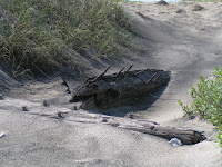
We had quite a busy day on Wed. as the three of us took off for the north end of the island towards Kitty Hawk. On our way we stopped at Coquina Beach where the ruins of the shipwrecked Laura A. Barnes lie. She was a 120-foot wooden four-masted schooner that went down in a dense fog in the Outer Banks during a Nor'easter on June 1, 1921, but the entire crew was rescued by the men at the Bodie Island Coast Guard Station. Over the years storms and hurricanes have broken up parts of the ship, and the constantly shifting sands from the winds have covered and uncovered the ship many times. So what remains is really not much to see, but hey, we can say we saw what was there!

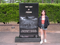
From here we headed for the Wright Brothers National Memorial, which is actually located in the town of what is now Kill Devil Hills. People often mistakenly think that Kitty Hawk is where the Wright brothers conducted their famous experiments with flight (we were some of those people). But actually the brothers just stayed for awhile with the Tate family in their Kitty Hawk home and conducted those first flights at a nearby field. We had also thought that the first flight took off from the top of a hill, but we were wrong on that, too. They actually landed at the same level as they took off! At the Wright Brothers National Memorial we viewed a number of exhibits outlining their story, a full-scale reproduction of the flying machine, and listened to a Park Ranger’s presentation on how the plane worked. The photo at the right is an enlarged copy of an actual photo taken that day of the first flight. We then went outside where a large granite boulder marks the spot where that first airplane left the ground and four numbered markers indicate the distance of each of the four flights made on that day. As you walk around and look at the exhibits, and get a better understanding of what they accomplished, you are truly taken back in time. Two bicycle makers from Ohio building a flying machine….amazing! Although their original principles have been refined over the years, the basic way of controlling a plane have not really changed much. That first flight was truly an extraordinary journey that covered 120 feet in 12 seconds. A small piece of the wing and the fabric flew to the moon with Armstrong, Aldrin, and Collins in 1969….Kitty Hawk to Tranquility Base and back.


We drove a little further north towards the actual town of Kitty Hawk to visit the Monument to a Century of Flight, which was dedicated in 2003 on the centennial of powered flight (http://www.monumenttoacenturyofflight.org/). At the entrance is a granite marker inscribed with the poem “High Flight”. The words were written by James Magee, Jr., a 19-year-old American pilot, and recorded in song by John Denver. There’s a time capsule buried next to the marker that is to be opened in 2103. The monument itself consists of 14 wing-shaped stainless steel pylons ascending in height from 10’ - 20’ in an orbit of 120’, the distance traveled by the Wright brothers on that first flight. Each pylon contains a black granite panel engraved with language and images about 100 of the most significant accomplishments in aviation in its first century from earthbound to the moon and beyond. Inside the orbit of pylons is a courtyard of 4,600 bricks engraved with messages of sponsors from around the world. The orbit of pylons culminates in a center bronze dome, six feet in diameter, depicting the continents of earth joined by a centennial message coming from Kitty Hawk.

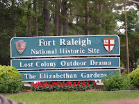
After stopping for a quick bite at Taco Bell/KFC, we drove over to Roanoke Island to check out Fort Raleigh, an earthen fort reconstructed exactly as it was built in 1585 on the exact location and operated by the National Park Service. It was England’s first attempt at a colony in the new world, but it did not go well. Named after Sir Walter Raleigh, the chief planner for this expedition, the “Citie of Raleigh” was to be located at the lower end of the Chesapeake Bay, but when they stopped briefly at Roanoke Island to re-supply, the boat pilot decided it was too far into the summer to go further and left the colonists there. John White was appointed Governor and worked at peaceful negotiations with the Indians, but because of earlier clashes with previous visitors and miscommunications, there was an uneasy coexistence among them. During this time, White’s daughter gave birth to the first English child born in the New World and was named Virginia Dare, a name that is used throughout the region. Shortly after the birth, Governor White was forced to return to England for badly needed supplies, but with his ship being forced into service against a prevailing war, he was not able to return for 3 years. When he did return to the colony, there was no sign of the 116 colonists anywhere. Even the houses had been taken down. Only the letters ‘CROATOAN”, the name of a nearby island, was carved into a tree. Raleigh made several attempts over the next 12 years to find any trace of them but none was found. On the 355 acres of Fort Raleigh National Historic site archaeological digs are still being performed today with new, modern technology in the hopes of finding some clue as to what happened. It is referred to as the “Lost Colony” on which an outdoor symphonic drama is performed during the summer months. Also, at this site during the Civil War, slaves escaping the mainland flocked to the protection of the Union army, and a formal colony was established in 1863 called Freedmen's Colony. Freedmen's Colony is recognized as a historic National Underground Railroad Network to Freedom Site, and a marker was erected in 2001.
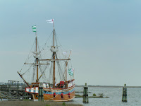
Driving through the historic district of the northern end of Roanoke Island through the town of Manteo, we passed the Elizabeth II ship, a replica of the 16th century ship that transported those who became known as the “Lost Colony”. This ship was built in 1983 to commemorate the 400th anniversary of the first English settlement in America.

On our way back to the campground, we passed Jockey's Ridge State Park, home to the East Coast's tallest natural sand dune that consists of 420 acres, is 1.5 miles long, and about 100 feet high (you are able to climb to the top). Geologists believe that Jockey's Ridge was formed when strong water currents from hurricanes and storms washed sand from large offshore shoals onto the beach. Throughout many years, the wind picked up this sand and blew it inland. These tiny grains of sand evolved into a system of dunes that now stretches for many miles along the coastline.
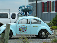
We made one last stop at Sugar Shack Seafood and picked up a couple fresh tuna steaks. (Scott isn’t into seafood very much.) Located right on the Manteo Causeway, they get ships dropping off fresh fish and seafood daily, and the steaks were very tasty.

The day before we’re set to leave for our next destination, we generally begin doing some preliminary work putting stuff away so we have less to do in the morning. Thurs. afternoon we emptied the black and grey water tanks (toilet and sinks), and while bending over to collapse the sewer hose support, I hit the top of my head on the corner of the slideout. Now I’ve hit it a couple times early on in our adventures, but it never bled and I’ve been extremely cautious since. However, this time I misjudged my location, and this time it did bleed. Russ was a great nurse and said he didn’t think it needed stitches, although he said it was nasty looking! During the next few days he diligently applied peroxide and Neosporin to keep it from becoming infected. He also made me wear a hat when out in the sun as he was concerned that with a layer of skin missing, it might readily burn (sorry no pictures!) So here it is 4 days later, and Russ still checks it a few times a day to make sure no infection has set in. Earlier today Russ suggested that washing my hair might be appropriate in the next day or two, which I’ll be glad to do!

Thursday, May 22, 2008

The Outer Banks

Win-deeeee!!! That's the best way to describe it here on the Outer Banks! It's been quite windy everyday we've been here so far. There were even a couple nights when a storm rolled in, the wind reached about 45 mph, and the RV was a-rockin'! For those of you who may not know, the Outer Banks are a group of islands on the North Carolina coast that separate the Atlantic Ocean from the coastal sounds and inlets. These islands with their beaches, sand dunes, marshes, and woodlands are all part of the Cape Hatteras National Seashore operated by the National Park Service (http://www.nps.gov/caha/). Oh, and there are about a dozen geese here at the Camp Hatteras Campground that pretty much have free rein of the grounds and leave their droppings everywhere!

Generally we travel on Mondays to our next destination (to avoid a lot of the traffic), then spend the weekdays sightseeing (to avoid the crowds), and hang around home on the weekends. But this leg of the journey we traveled on Friday because of Memorial Day weekend next week which sort of dictated travel and reservations. One of the disadvantages of a Coast to Coast membership is that participating resorts and campgrounds have blackout dates for members over holidays. Thus we will be staying at a KOA in Virginia Beach at the prevailing rate of roughly $60/night. Yes, we realize it will be crazy busy there over Memorial weekend, but remember…we live in our RV fulltime so have to stay somewhere!

The day we left Chocowinity was overcast with occasional rain the entire trip. But on the way we drove by some beautiful fields of flowers, crossed several bridges, and passed by the Bodie Island Lighthouse (pronounced like body). Though the tower remains closed to the public, it is still a functioning navigational aid for ships at sea. For more info on this lighthouse, go to http://www.nps.gov/archive/caha/bodielh.htm.


Anyway, since we arrived at Waves, NC, on Fri., we really didn't go anywhere over the weekend except that Russ and I walked down to the beach at least 2 or 3 times a day. We’ve checked out high tide and low tide. As mentioned before, Russ is not really a beach person so he still wore his tennis shoes and avoided getting them wet. In fact, I’m not sure who ran from incoming water faster, Russ or the little shorebirds! They do have some fast little legs and are funny to watch (I’m referring to the birds, of course.) I, on the other hand, wear shorts and my flip-flops pretty much no matter the temp so I can walk along the edge of the water barefoot and not worry about getting pants legs wet. The water temp up here is cooler than it was in Myrtle Beach. If you remember the water temp there was about 71…here it’s about 61! When we've walked in the late afternoon or early evening, I generally wear a jacket or light sweater because it’s fairly breezy and cool. The beach here is loaded with shells, most broken from the pounding and crashing of the waves, but we’ve found some intact and been collecting some on our walks (not sure what we’re going to do with them). It is amazing all the variations in color the various types of shells have. We also took some time to finally watch From the Earth to the Moon, that wonderful series that was on HBO a couple years ago produced by Tom Hanks. We had purchased the DVD set before we hit the road and had never cracked the cellophane on it till this weekend. If you haven’t seen it, it’s well worth the watch if you get the chance....excellent series.

On Monday Scott, Russ, and I drove down to the south end of the island to visit the famous Cape Hatteras Lighthouse, the tallest lighthouse in America. It’s located in this particular spot to warn travelers off shore in this area known as the "Graveyard of the Atlantic”, so named because of the large number of ships that have run aground because of the shifting sandbars. In the past 500 years nearly 2,000 ships have sunk in this area. During the Civil War, the lighthouse was attacked by both Union and Confederate forces, and over the years, three different Cape Hatteras Lighthouses have existed. The lighthouse is still operational with the light able to be seen for nearly 20 miles in good clear conditions. It stands 208 feet tall and has 268 steps to the top (which we chose not to climb). We were fortunate to arrive just in time for a presentation by a Park Ranger on the history of the lighthouse.

On the way to the lighthouse, we had passed a sign noting a Civil War Marker was at the next turn. It marked the spot where a Union ship was captured in 1861, its ammunition and supplies delivered to the Confederate troops, and then put into service for the Confederate troops 3 days later. There was really nothing to see other than a placard with all this info but within walking distance was a small cemetery surrounded by a picket fence. It didn’t appear that anyone famous was buried there and most died in the early to mid-1900s, but was a peaceful little scene with the headstones facing out towards Pamlico Sound.

After our visit to the lighthouse, it was time for lunch. We had been told at the visitor center on our way to the island about a restaurant called Quarterdeck that was not far from the lighthouse. There seems to be no shortage of restaurants on the islands, and I’m sure that during tourist season (which begins Memorial weekend) the places are packed. We could find hardly any info on Quarterdeck but since it had come very highly recommended by the couple at the visitor center, we decided to give it a try. It’s nothing pretentious, in fact looks like a simple white house on the outside and nothing fancy inside. Our waitress wasn’t the best but the crab bisque we all ordered to start things off was phenomenal! Piping hot and thick with lots of crab meat! The rest of our meal was tasty, so it had been a good choice after all.

Driving back we encountered this unique little “house” with alien creatures drawn on some of the windows. It appears to have a furnace, smoke stacks, and you could see a small mirror through one of the windows so we’re assuming someone lives in it. That night Russ and I went to the beach a little later than we had been going and got to see the moon rise over the ocean. What a beautiful sight.


Tues. we hung around the RV most of the day and then took Mikey and Abby to the beach late afternoon shortly before a storm rolled in. As usual Mikey pretty much just walked along the water's edge while Abby ran and played in and out of the water!