[Click on any photo to enlarge.]
*Critters we’ve seen on our
2015 trip so far: elk, mule, mule deer
*Birds we’ve seen on our 2015
trip so far: California condor, Brewer’s blackbird, American kestrel
*National Parks/Monuments visited on 2015 trip so far: 2
 Our next
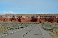
destination was going to be near the northeastern edge of AZ in the Navajo
Nation passing by some amazing landscapes including the Painted
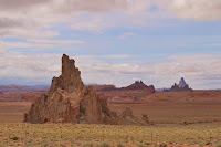
Desert and this rock formation known as Elephant Feet along Hwy.
160 (a road we’d never traveled before). Layers of rock
 created and carved by millions
of years of sedimentation, the rise and fall of the oceans, uplift, volcanoes,
earthquakes, and erosion make for some incredible scenery.
 Navajo
Nation is the largest reservation in the U.S. at 27,425 square miles overlapping into three
states…AZ, UT, and NM. It’s for this
reason that there are two time zones in AZ since the state is one of two (the
other being Hawaii)
 that does not follow Daylight Savings Time.
So in the summer while most of AZ is on west coast time, the Navajo Nation
is on Mountain time.
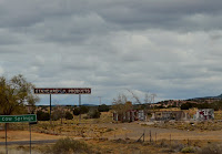 Rock formations and amazing vistas are not the only
things to see. Near Cow Springs, AZ,
we passed an abandoned Standard Oil Products building covered with graffiti,
and about 25 miles further we drove under a coal slurry pipeline as we traveled
along Hwy. 160. Most of Navajo Nation is
open range which means you’ll find livestock roaming freely or just hanging out by the side of the road.
 We stopped in Kayenta,
AZ, at probably the best Burger King we've ever been in for a quick lunch
to go. It was
extremely clean and organized with excellent, super friendly customer service
plus there was a nice display inside about the WWII Navajo Code Talkers (I’d
left the camera in the RV). From the
parking lot, we could see some of Monument
Valley which can be
seen from various spots along the highway and a place we visited back in 2011.
 Canyon de
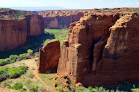
Chelly National Monument (www.nps.gov/cach) was where we were planning to spend the next few days. Pronounced canyon d’SHAY, this place is unique within the National Park Service in
that it is entirely located and owned by the Navajo
 Tribal
Trust Land
within the Navajo Nation. Established in
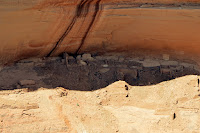
1931, it preserves the ruins of the Ancestral Puebloan people (also called
Anasazi) as well as the Navajo along three major canyons which can be viewed as
you drive along
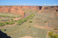 the canyon rims. The
monument covers 83,840 acres and about 40 Navajo families live in the park,
raising livestock and farming some of which can be seen from the canyon rim and
some you pass along the way.
 We had
only stopped at the visitor center when we passed through a few years ago, but
this time decided to stay a couple of nights at the Cottonwood Campground located within the
monument. Though I neglected to get a
photo of our campsite, I did manage to get one of an American kestrel situated
high atop a nearby tree.
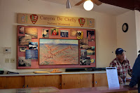 The next day we started at the visitor
center which is small and
had not changed since our last visit.
The gentleman pictured at right is a volunteer who makes custom jewelry at a booth right in the visitor center, and he told us that he was
raised in the canyon near the Sliding House ruins.
 Similar
to the Grand Canyon, Canyon de Chelly has
north and south rims, and we opted for the 37 mile roundtrip South Rim Drive. There are panoramic views of the canyon along
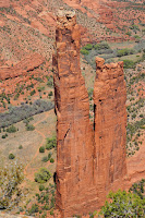
with ancient cliff dwelling ruins and spectacular geologic formations. One of the most distinctive of the geologic
formations is Spider Rock, an 800 foot tall freestanding sandstone spire rising
from the canyon floor at the junction of Canyon de Chelly and Monument Canyon. Access to the canyon floor is restricted
unless accompanied by a park ranger or Navajo guide (one
 exception is the 2-1/2
mile roundtrip White House Ruins Trail) so all viewing is from the many
overlooks. At every one of them (except
two) there are Navajo vendors selling their wares. They aren’t pushy and are very friendly but
still seems a little odd.

5 comments:
Will put on our list. Looks like a nice side trip. Thanks for posting.
Anybody that takes the time to keep up with your blog and the wonderful pictures has got to think you two are living the best life ever. Keep it up and stay healthy. Tom
Thank you for the interesting commentary and most especially the beautiful full color pictures. When I enlarge them on my computer the detail jumps right out and I get the feeling that I am right on the spot with you and Russ. I am really enjoying your travelogue of places that I may never get to see in person. Fred
Recvd your latest blog and Susan, I think you missed your calling - photos are great! You done good!!! Pls keep 'em coming 'cause we enjoy them. Fran
All I can say is SPECTACULAR! Sharon Kay
Post a Comment